
Is Layton Utah safe? It's the number one question I get from PCS families. Here's how to read Weber and Davis County crime data honestly — and how to check any street yourself.
Key Takeaways
- Citywide crime rates mislead. Retail corridors inflate numbers for cities that are quiet where people actually live.
- Pull numbers from the FBI Crime Data Explorer and each city's police department — not from ranking blogs.
- Property crime, not violent crime, drives almost every Northern Utah city's reported total.
- Ogden's citywide rate hides big neighborhood differences; the East Bench feels nothing like a downtown corridor.
- Drive your short list at 7am, 3pm and 9pm before you ever write an offer.
See What's For Sale Right Now
Browse every active Northern Utah listing on a live map — updated straight from the MLS.
In this article
- Is Layton Utah Safe? The Short Answer
- How to Read Crime Data — and Where to Find Real Numbers
- The Safest-Feeling Cities in Davis County
- The Safest-Feeling Cities in Weber County
- Is Ogden Utah a Safe Place to Live? The Honest Answer
- Why Roy, Riverdale, Clearfield and West Haven Look Different on Paper
- Weber & Davis County Cities at a Glance
- How Safe Is Utah to Live Compared to Other States?
- The Safety Factors Nobody Puts in a Crime Ranking
- Should You Actually Shop by Safety Ranking? Who This Is and Isn't For
- How to Check a Specific Street Before You Buy
- What Hill AFB Families Should Weigh Differently
Is Layton Utah Safe? The Short Answer
Layton is generally considered a safe suburban city, and most reported crime there is property crime rather than violent crime. Check current figures on the FBI Crime Data Explorer and Layton City Police Department's own reports before you decide.
Layton is a city of 82,512 people with a median household income of $99,188 and a median home value of $437,400, according to the U.S. Census Bureau ACS 2023 5-Year Estimates. That's a big, established, middle-to-upper-income suburb — the profile you'd expect to be low-crime, and in practice it is.
But here's the part the ranking blogs never explain. Layton has the largest retail corridor between Ogden and Salt Lake. Layton Hills Mall, the Antelope Drive shopping strip, big-box stores, hotels, restaurants. Every shoplifting incident, every car break-in in a mall lot, every hotel dispute gets reported to Layton PD and lands in Layton's citywide crime count.
Those incidents then get divided by Layton's residential population. So a city that pulls shoppers from four counties gets judged as if only its residents generated the crime. That math punishes commercial hubs and flatters bedroom communities.
If you live off Fort Lane, in Ellison Park, or up on the East Layton bench, your daily experience has almost nothing to do with what happens in a mall parking lot on a Saturday afternoon. Browse homes and neighborhoods in Layton to see how different the residential pockets are from the retail spine.
How to Read Crime Data — and Where to Find Real Numbers
Crime rates are incidents per 100,000 residents. Cities with malls, freeway exits, hospitals and hotels report crimes committed by visitors, which inflates their rate. Always separate violent crime from property crime, and read multiple years.
Three rules will save you from almost every bad conclusion:
- Split violent from property crime. In most Northern Utah cities, property crime is the overwhelming majority of reported incidents. A city can have a middling total and still see very few assaults or robberies.
- Watch the daytime population. Cities on I-15 with retail, hospitals and hotels serve far more people than live there. The denominator lies.
- Small cities swing wildly. In a town of 5,000, ten extra incidents can nearly double the "rate" year over year. One bad year is noise, not a trend.
The other trap is the ranking article. Most "safest cities in Utah" lists are built from a single year of data, sometimes from agencies that filed partial reports. A city can jump 30 spots because one department submitted a complete report that year.
Go to the source instead. Here's the checklist I give clients:
- The FBI Crime Data Explorer — search the specific agency (Layton City PD, Ogden City PD, Bountiful PD) and look at violent and property offenses separately, across several years. Start at fbi.gov.
- The city police department's own site — many post annual reports, monthly stats, and sometimes an incident map. This is the most current data available anywhere.
- State resources — utah.gov links to the Department of Public Safety and its statewide crime reporting.
- The Utah Sex Offender and Kidnap Offender Registry — a free public search run by the state, address by address.
- The non-emergency line. Seriously. Ask the records division what they see in a specific neighborhood. They answer.
One caution on the popular consumer crime-map apps: many scrape and interpolate, and their neighborhood "grades" are proprietary and unaudited. Use them to generate questions, not answers.
The Safest-Feeling Cities in Davis County
Kaysville, Farmington, Syracuse, Fruit Heights and West Point consistently read as low-crime, family-heavy suburbs. All are residential-first cities with high incomes, high owner-occupancy and limited highway-adjacent commercial activity.
Davis County's quietest cities share a profile: high median incomes, high homeownership, tight community structure, and not much commercial traffic pulling in outsiders.
Census ACS 2023 5-Year Estimates give you the income picture behind that. Kaysville has a median household income of $128,996 and a median home value of $583,700 across 32,861 residents. Farmington runs $120,432 and $618,400 across 24,934 residents. Bountiful sits at $103,723 and $488,900 across 45,093 residents.
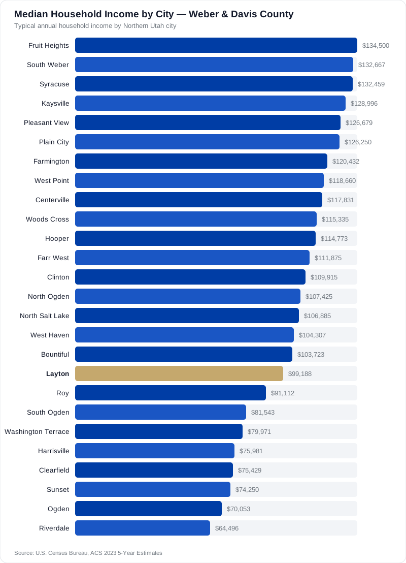
Income is not a safety measurement. Plenty of modest neighborhoods are wonderfully safe, and money doesn't prevent burglary. But income correlates with owner-occupancy and residential stability, and stability is the thing that actually shows up in low crime numbers.
Is Kaysville Utah safe? By every practical measure families care about, yes — it's a residential city with a strong school culture and almost no commercial through-traffic. Farmington is similar, with one caveat: Station Park and the Lagoon area bring significant seasonal visitor traffic that shows up in Farmington's reported numbers. See Kaysville, Farmington and Syracuse for what's actually on the market.
The Safest-Feeling Cities in Weber County
North Ogden, Pleasant View, Huntsville, Uintah and South Weber read as the quietest Weber County cities. They are small, residential, and set well away from the I-15 and Riverdale Road commercial corridors.
Weber County has more variation than Davis, because it contains both Utah's fourth-largest city and some genuinely rural mountain towns.
North Ogden is the biggest of the quiet ones — 21,473 residents, median household income $107,425, median home value $443,100 per Census ACS 2023 5-Year Estimates. It sits at the base of Ben Lomond with essentially no highway pass-through. If you're searching the north ogden crime rate, pull North Ogden PD's own annual report. It's a small, stable population where trends are easy to read year to year.
Pleasant View and Uintah are smaller and even more residential. Huntsville, up Ogden Canyon in the Ogden Valley, is a different world entirely — small enough that the sheriff's office handles most calls, where the real safety concern is winter canyon driving, not crime.
South Weber deserves a mention for military families. It's tucked between Layton and Riverdale with quick access to Hill AFB's south side, and it's residential top to bottom.
Start with North Ogden, Pleasant View and South Weber, or browse everything at the Weber County community hub.
Is Ogden Utah a Safe Place to Live? The Honest Answer
Ogden's citywide crime rate runs higher than its suburban neighbors, but Ogden is not one place. The East Bench, the upper avenues and revitalized historic districts feel very different from parts of the downtown corridor.
I'm not going to soften this: Ogden's citywide numbers are higher than Layton's, Kaysville's or North Ogden's. That's real. Ogden is the urban center of Weber County — 86,973 residents, a median household income of $70,053 and a median home value of $311,300 per Census ACS 2023 5-Year Estimates. It has a downtown, a rail history, a hospital, a university, a homeless services population, and the concentration of activity that comes with all of it.
And the citywide number is close to useless for a buyer, because Ogden's neighborhoods differ more from each other than most cities differ from each other.
The East Bench above Harrison — near Weber State and the McKay-Dee area — is a different environment from the blocks at the western end of the 25th Street corridor. Historic 25th Street itself has been substantially revitalized into a restaurant-and-shop destination. Neighborhoods like Shadow Valley and the upper avenues read as ordinary quiet suburbs.
So the honest answer to "is Ogden Utah a safe place to live" is: it depends entirely on which Ogden. Buyers who do the block-level homework often get the best value in the two counties — that $311,300 median home value is the lowest of any city on this list by a wide margin. Buyers who shop by price alone sometimes land somewhere they wouldn't have chosen. Ogden neighborhoods vary block by block, so call me before you write an offer on one you haven't walked.
Why Roy, Riverdale, Clearfield and West Haven Look Different on Paper
Roy, Riverdale, Clearfield and West Haven all sit on major commercial corridors near Hill AFB. Their reported crime is heavily retail-and-property driven, which raises citywide rates without matching the residential experience.
This is the single most misread group of cities in Northern Utah.
Riverdale is the clearest example. It's a small city that hosts the largest retail concentration in Weber County — Riverdale Road is wall-to-wall big-box stores. Retail theft happens where retail is. Those incidents get divided by Riverdale's small residential population, and the resulting "rate" looks alarming next to a bedroom community. Riverdale's residential neighborhoods are quiet, established and popular with Hill AFB families.
Clearfield (32,895 residents, median income $75,429, median home value $342,000) sits directly against Hill AFB with commercial frontage and a FrontRunner station. Roy (39,021 residents, median income $91,112, median home value $350,800) is a large working-family city on the same corridor. West Haven is one of the fastest-growing cities in the county, which brings construction-site theft — a real but very specific category.
Is Roy Utah a safe place to live? Is Riverdale Utah safe? For most families on most streets, yes — and both offer some of the best price-per-square-foot near the base. The variation within these cities matters far more than the citywide number. Look at Roy, Riverdale, Clearfield and West Haven.
Weber & Davis County Cities at a Glance
This table pairs each city's size, income and home value profile with the commercial factors that skew its reported crime rate. Verify current crime figures with each city's own police department.
All Census figures below are U.S. Census Bureau ACS 2023 5-Year Estimates. The right-hand column is the context raw crime rankings leave out.
| City | Population | Median Income | Median Home Value | What skews its reported rate |
|---|---|---|---|---|
| Kaysville | 32,861 | $128,996 | $583,700 | Almost purely residential |
| Farmington | 24,934 | $120,432 | $618,400 | Station Park and Lagoon visitor traffic |
| North Ogden | 21,473 | $107,425 | $443,100 | Very little pass-through traffic |
| Bountiful | 45,093 | $103,723 | $488,900 | Regional medical center, some retail |
| Layton | 82,512 | $99,188 | $437,400 | Largest retail corridor in the area |
| Roy | 39,021 | $91,112 | $350,800 | Corridor commercial, base-adjacent |
| Clearfield | 32,895 | $75,429 | $342,000 | Base-adjacent, FrontRunner, retail |
| Ogden | 86,973 | $70,053 | $311,300 | Urban center; huge neighborhood variation |
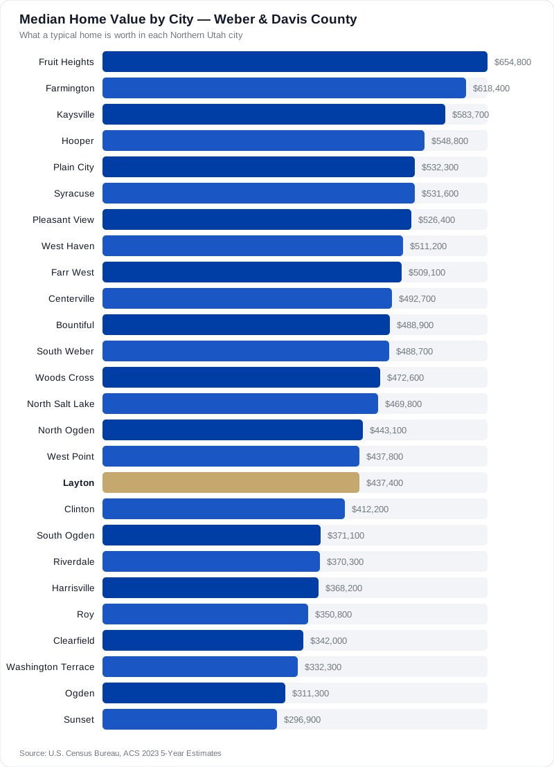
Notice the pattern: the cities people call "safest" are also the most expensive. That's not a coincidence, and it's not entirely about safety either. You're often paying a premium for reputation on top of the actual difference.
Free PCS to Utah Relocation Guide
Get my Hill AFB relocation packet — neighborhoods, VA loan tips, schools, and timelines — sent to your inbox.
How Safe Is Utah to Live Compared to Other States?
Utah generally reports lower violent crime than many states, with property crime closer to the middle. Check the FBI Crime Data Explorer for current state-level comparisons rather than relying on ranking articles.
If you're PCSing in from a large metro, the pattern most families notice is less violent crime and more opportunistic property crime than they expected — car break-ins, package theft, garage and construction-site theft.
That's the practical reality across the Wasatch Front suburbs. Cars left unlocked in driveways get gone through. Unlocked garages are a recurring theme in nearly every police department's community bulletin in both counties.
The highest-value safety habit here is boring: lock your car, close your garage. A large share of the property crime in these suburbs is opportunistic, not forced entry. That is genuinely the difference between being a target and not being one.
For actual state-versus-state numbers, use the FBI's Crime Data Explorer, which publishes state-level estimates alongside agency data. Don't take a figure from a listicle when the primary source is free and public.
The Safety Factors Nobody Puts in a Crime Ranking
In Northern Utah, winter driving, wildfire interface risk, air quality inversions, and canyon flood or debris zones affect daily safety more than crime does for most families. Check these alongside crime maps.
Every family I work with asks about crime. Almost none ask about these — and these are what actually change your day-to-day.
- Winter driving and road grade. A steep bench street that faces north can hold ice for weeks. Ogden Canyon, Weber Canyon and the North Ogden Divide demand real winter tires. Ask what a street looks like in February, not September.
- Wildland-urban interface. Homes at the top of the bench sit against dry foothills. Ask about defensible space and check with the local fire district.
- Inversion and air quality. Wasatch Front valleys trap cold air in winter and air quality drops. Bench and foothill homes often sit above the worst of it. The State of Utah publishes current readings through its Division of Air Quality.
- Flood, debris flow and irrigation channels. Some canyon-mouth neighborhoods sit in mapped hazard zones. Your title work and the county GIS will tell you.
- Public health and emergency services. The Weber-Morgan Health Department is a good starting point for county-level health resources.
I'd rather you buy in a slightly higher-crime-rate city on a flat, well-plowed street than a "safest city" home on a north-facing ice slide. That's the honest tradeoff nobody puts in a ranking.
Should You Actually Shop by Safety Ranking? Who This Is and Isn't For
Shopping by citywide safety ranking makes sense if you have zero local knowledge and need a starting filter. It's a poor primary strategy for anyone with a budget ceiling, a commute constraint, or specific school needs.
Here's where I'll be straight with you, because this is the part that earns the phone call.
Safety rankings are a reasonable starting filter if you're PCSing sight-unseen from across the country, you have no local contacts, and you need to narrow 30 cities down to six before you fly out for a house-hunting trip. Fine. Use them that way, then throw them away.
Safety rankings are a bad primary strategy if:
- You have a firm budget. The "safest" list and the "most expensive" list are nearly the same list. Chasing a ranking can push you out of the market or into a payment that strains you every month.
- You have a hard commute constraint. If you report at 0630, a longer drive from a higher-ranked city costs you real hours and real winter risk.
- You need a specific school or program. Special education services, dual immersion, a particular high school program — those are school-boundary questions, not city-crime questions.
- You're comparing cities of very different sizes. A 3,000-person town's rate is statistical noise. Don't buy on noise.
The families who do best here pick a neighborhood, not a city. They drive it, they check the block, and they weigh safety against commute, budget and schools instead of letting one number decide. If you're coming in on orders, the Hill AFB PCS relocation guide walks through that sequence, and the free 208-page relocation guide goes city by city.
How to Check a Specific Street Before You Buy
Drive the block at 7am, 3pm and 9pm on a weekday plus once on a weekend night. Then call the police records division, search the state offender registry, and talk to two neighbors.
Citywide data gets you a short list. This gets you an answer.
- Drive it four times. Weekday 7am (commute and school traffic), weekday 3pm (kids out, who's around), weeknight 9pm (lighting, noise, parking), and Saturday night. A street can be four different places.
- Look at the neighbors' houses, not the listing. Maintained yards, kids' bikes, cars in driveways, working porch lights. Deferred maintenance across a whole block tells you more than any statistic.
- Call the police non-emergency records line and ask what they see near that address. It's a public question and they'll answer it.
- Search the state offender registry by address radius. Free, official, takes two minutes.
- Knock on two doors. Ask how long they've lived there and what they'd change. People tell you the truth about their own street.
- Check lighting, sidewalks and through-traffic. Cut-through streets and poorly lit dead-ends behave differently than they look on a map.
Do this on your top three homes and you'll know more than any ranking site could tell you. When you're ready to build that short list, browse live MLS listings or work through the Davis County and Weber County community pages.
What Hill AFB Families Should Weigh Differently
Military families should weigh gate commute, deployment-period support, and resale liquidity alongside crime data. A safe city with a 40-minute winter commute may not be the right call for your family.
If you're reporting to Hill Air Force Base, your safety calculation carries factors a civilian buyer doesn't.
Deployment matters more than the crime rate. If your spouse will be solo with kids for six months, the density of other military families nearby, proximity to the base, and how well-lit and connected the street is will matter far more than a decimal point in a citywide statistic. That's a big reason Layton, Clearfield, Roy, South Weber and Syracuse stay so popular with Air Force families.
Gate access matters. Which gate you use changes which cities are actually convenient. A city that's ten minutes closer to your gate gives you back real time every winter morning.
Resale liquidity matters. You may be selling in three years on someone else's timeline. Cities with steady military demand tend to move faster. Ask me about that before you buy something unusual.
Financing is its own topic — if you're using your VA benefit, start with the VA's home loan page and read the dedicated VA loan posts on this site. Get the neighborhood right first; the loan follows.
Thinking About a Move? Let's Talk.
Call Donald I. Gomez for straight answers on Northern Utah real estate — no pressure, just local help.
Frequently Asked Questions
Is Layton Utah safe for families with kids?
What's the safest city in Utah?
Is Bountiful Utah a safe place to live?
Is Ogden Utah safe? I keep seeing mixed things online.
Is Syracuse Utah a safe place to live?
Is West Haven Utah a safe place to live?
How safe is Utah to live compared to where I'm moving from?
Should I pay more to live in a 'safer' city near Hill AFB?

Donald I. Gomez
Donald helps buyers, sellers, and PCSing military families move across Northern Utah — from Ogden to the Wasatch. A longtime Hill AFB-area local, he tours new builds and resale homes every week on his YouTube channel.


